Kenai Peninsula
The Kenai Peninsula (Dena'ina: Yaghenen) is a large peninsula jutting from the coast of Southcentral Alaska. The name Kenai (/ˈkiːnaɪ/, KEE-ny) is derived from the word "Kenaitze" or "Kenaitze Indian Tribe", the name of the Native Athabascan Alaskan tribe, the Kahtnuht’ana Dena’ina ("People along the Kahtnu (Kenai River)"), who historically inhabited the area.[1] They called the Kenai Peninsula Yaghanen ("the good land").[2]
Geography
[edit]
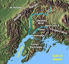
The peninsula extends about 150 miles (240 km) southwest from the Chugach Mountains, south of Anchorage. It is separated from the mainland on the west by Cook Inlet and on the east by Prince William Sound. Most of the peninsula is part of the Kenai Peninsula Borough. Athabaskan and Alutiiq[3] Native groups lived on the peninsula for thousands of years prior to colonization during the Russian America era.
The glacier-covered Kenai Mountains run along the southeast spine of the peninsula along the coast of the Gulf of Alaska. Much of the range is within Kenai Fjords National Park. The northwest coast along the Cook Inlet is flatter, dotted with numerous small lakes. Several larger lakes extend through the interior of the peninsula, including Skilak Lake and Tustumena Lake. Rivers include the Kenai River, renowned for king salmon fishing,[4][5][6][7] Each year there are two runs each of king salmon, coho salmon, sockeye salmon, plus a run of pink salmon every other year. The world record king salmon, which weighed about 44 kg (97 lb), was caught in the Kenai River in 1985.[8] and its tributary, the Russian River, the Kasilof River, and the Anchor River. Kachemak Bay, a small inlet off the larger Cook Inlet, extends into the peninsula's southwest end, much of which is part of Kachemak Bay State Park.
It is home to both the Sargent Icefield and Harding Icefields.
Towns and cities
[edit]The peninsula includes several of the most populous towns in Southcentral Alaska, including Seward on the Gulf of Alaska Coast, Soldotna, Kenai, Sterling, and Cooper Landing along the Cook Inlet and Kenai River, and Homer, along Kachemak Bay, along with numerous smaller villages and settlements.
Transportation
[edit]Homer marks the terminus of the paved highway system of North America. Seward is the southern terminus of the Alaska Railroad. The Seward Highway connects Seward to Anchorage, and the Sterling Highway is the backbone of Kenai Peninsula connecting the larger towns to Anchorage.
Natural resources and economy
[edit]The peninsula also has natural gas, petroleum, and coal deposits, as well as abundant commercial and personal-use fisheries. Tourism is a major industry, along with outfitting and guiding services for hunters and fishers. The Kenai Peninsula is known as "Alaska's Playground".[9] Kenai National Wildlife Refuge encompasses nearly two million acres of the peninsula.[10]
References
[edit]- ^ "Kenai Peninsula". Geographic Names Information System. United States Geological Survey, United States Department of the Interior.
- ^ Kenaitze Indian Tribe
- ^ "Alutiiq / Sugpiaq People". alutiiqmuseum.org. Retrieved May 7, 2023.
- ^ "The Kenai River" (PDF). Alaska Department of Fish and Game.
- ^ "About KRSA". Kenai River Sportsfishing Association. Archived from the original on 2012-11-09. Retrieved 2009-12-03.
- ^ "Kenai River Facts". Mystic Fishing.
- ^ "Boat Waves on Johnson Lake and Kenai River, Alaska. - Final rept". U.S. Department of Commerce. Archived from the original on 2008-10-03.
- ^ "Kenai River Salmon Runs". 20 February 2014. Archived from the original on 26 August 2014. Retrieved 24 August 2014.
- ^ Nikiforuk, Andrew (2011). "The Alaska Storm". In Pulling, Barbara (ed.). Empire of the Beetle. Greystone Books. p. 5. ISBN 978-1553655107.
- ^ KNWR website


